
Unlocking Convenience: Nagpur Division’s Digital Access Map

Passenger Amenities: In a groundbreaking move aimed at revolutionizing the passenger experience within the Indian Railways network, Nagpur Railway Station, a pivotal hub, has introduced an innovative Digital Access Map. Spearheaded by the Nagpur Division of Central Railway, this initiative marks a significant leap towards enhancing passenger convenience and accessibility across 25 key railway stations in the division.
Navigating Convenience: Understanding the Digital Access Map
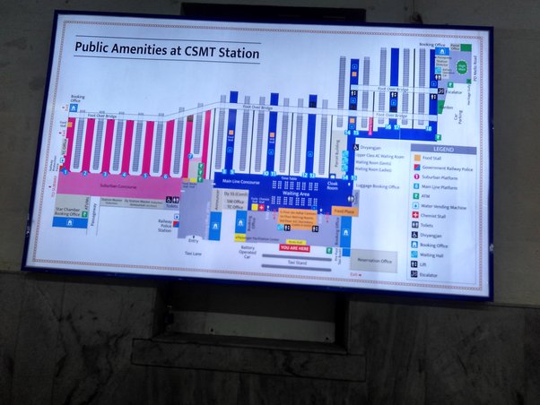
The Digital Map stands as a trailblazing pictographic representation, illustrating the precise locations of various passenger amenities across the station premises. Its intuitive design provides passengers with comprehensive guidance, mapping out essentials such as waiting rooms (reserved and unreserved), Divyang (specially-abled) ticket counters, lavatories, water taps and coolers, lifts, foot over bridges, entry and exit points, and the RPF Thana (Railway Protection Force Station). Moreover, the setup is thoughtfully back-lit, ensuring clear visibility even during nighttime.
Empowering Passengers: The Utility of the Digital Map
Crafted with the passenger’s convenience in mind, this digital map emerges as an indispensable tool for efficient navigation of the railway infrastructure. Offering clear visual cues and precise information about amenities available on different platforms and within the station area, it empowers passengers to make informed decisions and swiftly access the facilities they require, thereby streamlining their travel experience.
Current Implementation and Future Expansion
Presently operational at 25 stations across the Nagpur Division, the Digital Access Map is slated for swift implementation at the remaining stations. This proactive approach ensures that every passenger within the division benefits from this innovative solution. Among the stations where the Digital Access Map is already operational are Nagpur, Wardha Sewagram, Chandrapur, Ballarshah, Warora, Hinganghat, Bhnadak, Katol, Narkher, Pulgaon, Dhamangaon, Chandur, Pandhurna, Multai, Amla, and Betul.
In conclusion, Nagpur Division’s introduction of the Digital Map stands as a testament to its commitment to enhancing passenger convenience and accessibility. With its user-friendly design and comprehensive coverage, this initiative promises to redefine the passenger experience within the Indian Railways network.

1. How does the Digital Access Map benefit passengers?
- The Digital Map provides clear guidance on the locations of various passenger amenities, streamlining the navigation process for travelers.
2. Is the Digital Map available at all railway stations within the Nagpur Division?
- While currently operational at 25 stations, plans are underway to implement the Digital Access Map at all stations within the division.
3. Can visually impaired passengers utilize the Digital Access Map?
- Efforts are being made to ensure accessibility for all passengers, including those with visual impairments, through alternative formats and technologies.
4. Are there plans to incorporate additional features into the Digital Access Map in the future?
- Yes, the Nagpur Division aims to continually enhance the Digital Access Map with additional features based on passenger feedback and technological advancements.
5. How can passengers provide feedback or suggestions regarding the Digital Access Map?
- Passengers can share their feedback and suggestions through designated channels such as customer service desks or online platforms provided by the railway authorities.